July 21, 2021
2620
Among the more than 80 cotton producing countries in the world, China, the United States, India and Pakistan are the largest cotton producers and consumers. The output and consumption of these four countries account for approximately 60% of the world’s total cotton production and consumption. %. Xinjiang, China, is blessed with natural conditions, alkaline soil, large temperature difference in summer, sufficient sunlight, sufficient photosynthesis, and long growth time. The cotton grown in Xinjiang is famous for its long velvet, good quality and high yield. With the acceleration of land circulation in Xinjiang, large-scale planting, and the improvement of technical level, the army of cotton picking in Xinjiang has gradually faded out of people's sight, and mechanized planting and harvesting of cotton has become the mainstream. Looking to the future, after full mechanization, more new technologies will penetrate into the agricultural field, which will greatly promote the development of agriculture in the future. In the future, agriculture is developing in the direction of automation, intelligence, digitization, informatization, and interconnected smart systems. On May 16, 2019, the General Office of the Central Committee of the Communist Party of China and the General Office of the State Council issued the "Digital Rural Development Strategy Outline", pointing out that the new generation of information technology innovation has been unprecedentedly active, and it has continuously spawned new technologies, new products and new models, and promoted the global economic structure and development. With the profound changes in the industrial form, there is an urgent need to further explore the huge potential of informatization in rural revitalization, and promote the overall upgrading of agriculture, the overall progress of the countryside, and the overall development of farmers. One of the key tasks is to consolidate the foundation of digital agriculture, improve the "one map" of remote sensing monitoring of natural resources and the comprehensive supervision platform, and implement dynamic monitoring of permanent basic farmland. In this context, this article mainly introduces the application of precision agriculture technology, remote sensing technology and UAV low-altitude remote sensing technology in field crop monitoring and yield prediction.
1 Precision agriculture technology
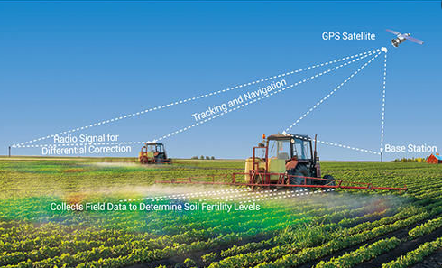
Precision agriculture is a new development model in the agricultural development model. It mainly combines information technology with various high and new technologies, and modernizes agricultural management and operations according to changes in space, geography, time and environment, forming a type suitable for large-scale crop planting. The modern agricultural production model is shown in Figure 1. 3S technology (geographic information system GIS, global satellite positioning system GPS and remote sensing technology RS technology) is the core technology of precision agriculture technology, which can process, manage and analyze the information collected by field agriculture , Expression, dissemination and application have played a significant role in promoting the development of my country's agricultural construction. Crop production management decision support system, crop condition and sensor technology, variable spray control technology and equipment and other related technologies promote the rapid development of precision agriculture technology. According to data from 2018, 30% to 50% of large-scale farms in the United States have applied precision agriculture technology. The larger the farm, the higher the profit provided by precision agriculture technology and the shorter the cost recovery period. At present, in the field of precision agriculture technology, soil maps, yield maps, navigation systems and variable technologies are the most widely used. In the context of the continuous development of the current level of agricultural mechanization in my country, precision agriculture is of great significance in improving the level of agricultural production management, rational use of resources and environmental protection benefits.

2 Remote sensing technology
As one of the supporting technologies of precision agriculture technology, remote sensing technology
[4] It is a kind of one used for large-area and long-distance information collection and monitoring.
A new type of non-destructive and penetrating detection technology, which can obtain real-time data in a wide range and at different times, and reflect the nature of all aspects of objects in detail through remote sensing images, allowing people to obtain natural and unnatural environments in a short time Basic Information. At high altitudes and long distances, the electromagnetic wave information radiated or reflected by the object is received through remote sensing technology, and information processing technology is applied to process it into a recognizable image. The analysis reveals the nature, shape and dynamic changes of the object. At present, remote sensing technology is widely used in many fields such as mineral exploration, environmental monitoring, agriculture and animal husbandry.
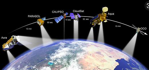
Since the beginning of the research on remote sensing technology on the ground, agricultural remote sensing technology has always been the key research direction of spaceborne remote sensing and airborne remote sensing. Using satellite-borne remote sensing and airborne remote sensing to operate farmland, obtain large-scale crop planting biological and physical information, which is helpful for large-scale crop management. With the advancement of hyperspectral technology and the development of specialized small satellites for ground detection, remote sensing technology will become the driving force for the rapid development of my country's digital agriculture, precision agriculture, and ecological agriculture [6]. The observation range of satellite remote sensing is relatively large, and the observation information is relatively macroscopic and comprehensive, which can realize long-term continuous monitoring, but the image resolution is not very high.

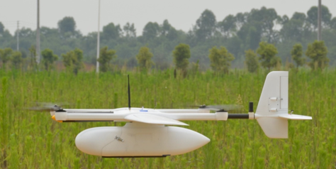
In recent years, the unmanned aerial vehicle remote sensing (Unmanned Aerial Vehicle Remote Sensing), which has gradually developed and expanded, uses advanced UAV platforms to achieve automation, intelligence, and special rapid acquisition of space remote sensing information, and complete remote sensing data processing, modeling and application analysis. Compared with satellite remote sensing, UAVs have a relatively small observation range because they are close to the ground, but they have high image resolution, are flexible and easy to deploy, have good timeliness, and can shoot video images.

3 UAV low-altitude remote sensing technology
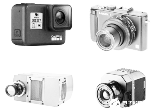
Plants have spectral characteristics and can absorb, reflect, and radiate different spectra. UAV low-altitude remote sensing technology is based on the spectral characteristics of plants. Different wavelengths of light have different effects on plant growth. UAVs are equipped with image sensors, such as visible light cameras, multispectral cameras, hyperspectral cameras, and thermal imaging cameras. It is used to collect images of crops in different wavebands and extract different features, as shown in Figure 4.
In the entire available electromagnetic spectrum, image data of different bands are used to extract different characteristic parameters of crops:
(1) The visible light band (VIS) of 400~700 nm is used to measure the morphology, geometric characteristics and color characteristics of plants;
(2) The near infrared band (NIR) of 700~1 000 nm is often used to detect the water content of leaves;
(3) The thermal infrared band (TIR) of 7 500~13 000nm is often used to detect the spectral reflection of leaves under different temperature conditions, and can also reflect the water content;
(4) The hyperspectral camera collects hundreds of spectral bands from 350-2 500 nm to measure and reflect plant stress conditions;
(5) The chlorophyll fluorescence image measured under excitation light can be used to study the photosynthesis of plants.

UAV low-altitude remote sensing detects crop biological and physical information, which can quickly and effectively assess crop biomass and provide an efficient low-altitude management tool for large-scale crop cultivation. The application of drone low-altitude remote sensing technology in the agricultural field includes crop species identification, growth and moisture monitoring, pest monitoring, statistical analysis of plant numbers and seedling rate, soil attribute analysis, crop damage assessment after natural disasters, and crop yield prediction Wait. For example, Filippo SanTIni and others used drone multispectral, RGB and thermal imaging technology to test the genetic variation of vegetation index and canopy temperature in black pine populations, and evaluated the correlation between vegetation characteristics and above-ground populations. MaimaiTIjiang M et al. used drones to collect RGB image imaging of the soybean growing season in a field near Columbia, Missouri, and obtained the vegetation index weighted canopy volume model from the spectrum, structure and volume information derived from the RGB image. Estimate soybean biomass. In a typical large-scale farmland in Binzhou City, Shandong Province, Zhu Wanxue et al. used a fixed-wing UAV remote sensing platform to image data sets of winter wheat jointing stage, heading filling stage and maturity stage, and used the least square method to establish the linearity between different vegetation indexes and the measured yield of winter wheat Model to diagnose and evaluate crop condition and yield.
The following is an example to introduce the key points worth noting in the technical process and system research process of UAV low-altitude remote sensing gathering and transportation in the application of cotton production forecasting.
(1) Field trials and field data collection. After determining the research objectives and objects, record field trial conditions such as crop varieties, geographic location, planting, fertilization, irrigation and other crop management methods, and accurately collect field data such as soil conductivity Value, output value, etc.
(2) Use drones to collect low-altitude remote sensing images. Determine the type of image sensor carried by the drone. If possible, it is recommended to carry commonly used RGB visible light cameras, multi-spectral cameras including near-infrared bands, and thermal imaging cameras. At the same time, field images can be collected during multiple periods of crop growth to realize crop growth process detection.
(3) Use commercial software for data preprocessing, such as the Yield Editor output data processing software used in the literature, to remove unreasonable output data. Software vendors that provide cloud services for drones and DroneDeploy software stitch a large number of partial images of farmland into panoramic images.
(4) After obtaining the panoramic image, it is necessary to match the geodetic data with the image data, that is, register the GPS data recorded at harvest time into the image through geometric operations; this process is also very simple, find the iconic feature points in the field , The latitude and longitude coordinates can be confirmed in Google Maps, and then the pixel values of these feature points can be found in the image, which can be achieved through scale conversion.
(5) Divide the whole image into several sampling units according to GPS data. Each small unit has its GPS data, image data and output data, which forms a data set.
(6) For the extraction of characteristic parameters, the characteristic parameters must be able to clearly and fully reflect the differences of crops. Color models such as RGB, HSV, Lab can be used for analysis, and NDVI plant coverage and normalized difference vegetation index (NDVI) can also be used for analysis.
(7) Finally, it is the part of data statistical analysis and modeling. Generally, the entire data set is divided into 90% training set and 10% test set. The training set is used for modeling, and the test set is used to evaluate the accuracy of the prediction model. Based on multiple characteristic parameters, a multiple linear regression model can be constructed for yield prediction, and then the P value of the hypothesis test, the coefficient of determination R2, the average absolute error percentage MAPE (0.4 hm2) between the predicted value and the true value are used to evaluate the prediction model.
Through the above 7 main steps, the crop yield prediction application based on the UAV low-altitude remote sensing platform can be completed. Similarly, the above technical process can also be referred to in other applications.
4 Conclusion
This article briefly summarizes precision agriculture technology, remote sensing technology and UAV low-altitude remote sensing technology, enumerates the application of UAV low-altitude remote sensing technology in field crop monitoring and yield prediction, and introduces the application of low-altitude remote sensing vision and spectral images with an example Method of forecasting cotton production. In future research, the following aspects should be emphasized: (1) Platform design, a stable and reliable airborne platform is the basis for obtaining accurate and reliable sensor data; (2) Algorithm research, including. Image processing methods. Feature parameter extraction algorithms and big data analysis methods; (3) The integration and cooperation of multiple disciplines, and the intersection of agronomy, engineering and informatics can further promote the in-depth development of UAV remote sensing technology in the agricultural field. c